Moscow Central Circle (MKR) station diagram, interactive MCC station diagram on the map, detailed information, train schedule.
Interactive map of the Moscow Circle Railway (MCC map) and metro transfer stations, MCC train schedule
MCC fare
Tariffs for travel on the Moscow Central Circle (MCC).
- Ticket for one and two trips to the MCC – 57 and 114 rubles, respectively.
- Directions for card users “Troika” on the MCC – 40 rubles.
- "Unified" for 1 month; metro, trolleybus, bus, tram (no more than 70 trips on the metro/MCC) – 2900 rubles.
The “Single” ticket allows you to travel by metro, monorail, bus, trolleybus or tram. One trip on a ticket is equal to one pass on any type of transport. The ticket is valid throughout Moscow, including Zone B.
The validity period of a “Single” ticket for 1–2 trips is 5 days, including the day of sale.
Tariffs: off. website – mosmetro.ru/tariffs/unity/
- Transfers from the metro to the Moscow Central Circle and back are carried out without charging an additional fee.
The exception is transfers between stations Dubrovka MCC and Kozhukhovskaya metro station, as well as between stations Verkhnie Kotly MCC and Nagatinskaya metro station.
MCC operating schedule and train intervals
Trains operate on the MCC daily from 05:45 to 01:00 Moscow time.
- Weekdays: during rush hour 5 minutes. – (from 7:30 to 11:30 Moscow time and with 16:00 to 21:00 Moscow time)
- Weekends: during rush hour 6 min. – (from 13:00 to 18:00 Moscow time) and 10 minutes during off-peak times.
In accordance with the new schedule of the MCC, Lastochka makes 354 flights on weekdays, and 300 on weekends. For the convenience of passengers, at 12 stop points with the highest passenger traffic, the stop time of the train has been increased from 30 seconds to 1 minute.
These are the platforms “Andronovka”, “Lokomotiv”, “Rostokino”, “Botanical Garden”, “Vladykino”, “Okruzhnaya”, “Panfilovskaya”, “Business Center”, “Kutuzovskaya”, “Gagarin Square”, “Zil”, “ Avtozavodskaya". Thus, travel time on the MCC will increase from 84 to 90 minutes.
MCC train schedule
Detailed description of stations of the Moscow Central Circle.
KHOROSHEVO - SORGE - PANFILOVSKAYA - STRESHNEVO - BALTIC - KOPTEVO - LIKHOBORY - DISTRICT - VLADYKINO -BOTANICAL GARDEN-ROSTOKINO -BELOKAMNAYA -BOULEVARD-ROKOSSOVSKOGO-LOCOMOTIVE -IZMAILOVO -SOKOLINAYA MOUNTAIN -THE ENTHUSIAST HIGHWAY-ANDRONOVKA -NIZHNOGORODSKAYA -NOVOKHOKHOLOVSKAYA -UGRESHSKAYA -DUBROVKA -AVTOZAVODSKAYA -ZIL -UPPER BOILERS -CRIMEASKAYA -GAGARIN SQUARE-LUZHNIKI -KUTUZOVSKAYA -BUSINESS CENTER -SHELEPIKHA
Train schedule at TPU Khoroshevo station
– located in the Northern and Northwestern administrative districts of Moscow, within the boundaries of the Khoroshevo-Mnevniki and Khoroshevsky districts.
The main planning and transport connections of the territory are the MCC, Marshal Zhukov Avenue, 3rd Khoroshevskaya Street and Khoroshevskoye Highway.
The Khoroshevo transport hub is planned to provide a transfer to ground urban passenger public transport. It is planned to construct new stopping points with drive-in pockets for public transport on 3rd Khoroshevskaya Street and Marshal Zhukov Avenue.
To the east of this site Polezhaevskaya metro station is within walking distance Tagansko-Krasnopresnenskaya line.
The transport hub includes the construction of northern and southern passenger terminals, an overground pedestrian crossing with service facilities and a stopping point, consisting of a coastal and island platform, while the platforms are partially located directly on the overpass over the Khoroshevskoe highway and structurally form a single whole with it
Transport:
Train schedule TPU Sorge
TPU "Sorge"– located in the Northern and Northwestern administrative districts of Moscow, within the boundaries of the Khoroshevo-Mnevniki, Shchukino, Sokol and Khoroshevsky districts.

The main planning and transport connections of the territory are the MCC, Sorge, Berzarina, Marshala Biryuzova, 3rd Khoroshevskaya and Kuusinen streets. There is a station not far from the planned territory "October Field" Moscow metro.
The Sorge transport hub will provide a transfer to ground urban passenger transport. For this purpose, it is planned to construct a settling-turning area, construct new stopping points, with drive-in pockets for public transport on Sorge and Marshal Biryuzov streets.
Transport:
- Buses No. 48, 64, 39, 39k
- Trolleybuses No. 43, 86, 65
Train schedule TPU Panfilovskaya
TPU "Panfilovskaya" located in the Northern and Northwestern administrative districts of Moscow, within the boundaries of the Sokol and Shchukino districts.

It is planned to organize a convenient transfer from the Moscow Ring Railway to buses and trolleybuses stopping on nearby streets - Panfilov, Alabyan and Narodnogo Opolcheniya. It is planned to install new stopping points with drive-in pockets for public transport along Panfilov Street. Three elevated pedestrian crossings, passenger platforms on the MCC, exits to the platforms, premises for ticket offices and turnstiles are also being built.
The Panfilovskaya transport hub is located within walking distance from the Oktyabrskoye Pole station. Tagansko-Krasnopresnenskaya line of the Moscow metro.
Transport:
- Buses No. 100, 105, 26, 691, 88, 800
- Trolleybuses No. 19, 59, 61
Train schedule TPU Streshnevo
– located in the Northern and Northwestern administrative districts of Moscow, within the boundaries of the Sokol, Voikovsky, Shchukino and Pokrovskoye-Streshnevo districts.

The main planning and transport connections are the Moscow Circle Railway, the Riga direction of the Moscow Railway, 1st Voykovsky, Svetly and 1st Krasnogorsky passages, Konstantin Tsarev Street and Volokolamskoe Highway.
In 2017 a transfer to the Riga direction will be organized from the Streshnevo transport hub Moscow Railway, for which a new stopping point Streshnevo will be built. By the time passenger rail traffic on the MCC is launched, a transfer will be organized from the Volokolamskaya stopping point to ground urban passenger transport, settling and turning areas will be arranged, and new stopping points will be organized with the construction of drive-in pockets along the 1st Krasnogorsky Passage and Volokolamsk Highway.
Transport:
- Buses No. 88
- Trolleybuses No. 12, 70, 82
- Trams No. 23, 30, 31, 15, 28, 6
- Suburban railway transport Pl. Streshnevo (Riga direction of the Moscow Railway, promising, 2017)
Train schedule TPU Baltiyskaya
– located in the Northern Administrative District of Moscow within the boundaries of the Voikovsky district. The main planning and transport connections are Leningradskoye Highway, Admiral Makarov, Klara Zetkin streets, Novopetrovsky Proezd, 4th Novopodmoskovny Lane and Zoya and Alexander Kosmodemyansky Street.

The Baltiyskaya transport hub is located near the Voikovskaya station of the Zamoskvoretskaya line Moscow metro, and provides transfer to the metro. There will also be a transfer to city passenger transport (bus, trolleybuses and minibuses). It is planned to build settling and turning areas and install new stopping points for ground urban passenger transport along Admiral Makarov Street and Novopetrovsky Proezd. In the future, an overground pedestrian crossing will be built from Admiral Makarov Street to Novopetrovsky Proezd over the railway tracks.
From the pedestrian crossing there will be exits on both sides of the Baltiyskaya stopping point. The elevated pedestrian crossing will be connected to the Metropolis shopping center, from where it will be possible to access the metro. At the same time, a transition from the MCC to the metro and along the road network will be organized.
Transport:
Car parking:
Number of parking spaces: 1000, year of construction: 2025
Train schedule TPU Koptevo
– located in the Northern Administrative District of Moscow within the boundaries of the Golovinsky and Koptevo districts. The main planning and transport connections are Koptevskaya, Mikhalkovskaya, Onezhskaya streets and Cherepanov passage. At the intersection of the listed planning connections in the Mikhalkovskaya interchange area there is a tram ring of routes running from the Voikovskaya and Timiryazevskaya stations.

The transport hub project provides for the construction of a turnstile and ticket office pavilion, an elevated pedestrian crossing, providing access to the tram ring and public transport boarding fronts on the street. Mikhalkovskaya.
Transport:
- Buses No. 123, 621, 90, 22, 72, 801, 87
- Trams No. 23, 30
Train schedule TPU Likhobory
– located in the Northern Administrative District of Moscow within the boundaries of the Koptevo, Golovinsky, Western Degunino and Timiryazevsky districts.

The main planning and transport connections are the MCC, Oktyabrskaya Railway, Cherepanov Passage, Oktyabrskaya Railway Line Street and Likhoborskaya Embankment.
By the time passenger rail traffic on the MCC is launched, a transfer will be organized from the MCC station "Likhobory" to the NATI platform, as well as to ground urban passenger transport: the construction of a settling and turning area, the construction of new stopping points along Cherepanov Passage.
Transport:
- Buses No. 114, 123, 179, 204, 87
- Trolleybuses No. 57
- Suburban railway transport Pl. NATI (Leningrad direction of Railways)
- Car parking: Number of parking spaces: 200, Year of construction: 2017
Train schedule TPU Okruzhnaya
– located in the North-Eastern and Northern administrative districts of Moscow, within the boundaries of the Marfino, Otradnoe, Timiryazevsky and Beskudnikovsky districts. The main planning and transport connections are the MCC, the Savelovskoe direction of the Moscow Railway, Lokomotivny and 3rd Nizhnelikhoborsky passages and Station Street.

TPU "Okruzhnaya" will provide transfer to the eponymous stopping point of the Savelovsky direction of the Moscow Railway and on promising station "Okruzhnaya" Lyublinsko-Dmitrovskaya line of the Moscow metro (opening in 2017). It will also be possible to transfer to ground urban passenger transport.
Transport:
Train schedule TPU Vladykino
– located in the North-Eastern administrative region, districts: “Otradnoe” and “Marfino”. The Vladykino transport hub will provide a transfer to the Vladykino station Serpukhovsko-Timiryazevskaya line of the Moscow metro, as well as on ground urban passenger transport. An elevated pedestrian crossing will lead from the MCC platforms, which will go to the southern and northern lobbies of the Vladykino metro station.

The TPU project provides for the construction of an MCC station with the installation of ticket offices and turnstiles, an elevated pedestrian crossing over the railway, which will connect the southern and northern metro lobbies. It is also planned to build a settling and turning area for ground urban passenger transport.
Transport:
Train schedule TPU Botanical Garden
TPU "Botanical Garden"– located in the North-Eastern administrative district of Moscow in the Sviblovo, Ostankino and Rostokino districts. The main planning and transport connections are the passage and Serebryakova street, st. Wilhelm Pieck, 1st Leonov Street.
The Botanical Garden transport hub is located in close proximity to the Botanical Garden station. Moscow metro and will be connected to it by an underground pedestrian crossing. An underground pedestrian crossing will run under the railway and connect Serebryakov Passage and 1st Leonov Street.
Transport:
Train schedule TPU Rostokino
TPU "Rostokino"– located in the North-Eastern administrative district of Moscow. The territory borders the Yaroslavsky, Rostokino and Sviblovo districts.
The main planning and transport connections are Mira Avenue, Yaroslavskoe Highway, Severyaninsky Overpass.
The Rostokino transport hub will provide a transfer to the Severyanin stop point Yaroslavl direction of the Moscow Railway, as well as for ground urban passenger transport: reconstruction of existing and construction of new stopping points, construction of a settling and turning area along Mira Avenue towards Letchika Babushkina Street.
Transport:
- Buses No. 136, 172, 244, 316, 317, 388, 392, 425, 451, 499, 551, 576, 789, 834, 93
- Trolleybuses No. 14, 76
- Trams No. 17
- Suburban railway transport Pl. Severyanin (Yaroslavl direction of the Moscow Railway)
Train schedule TPU Belokamennaya
TPU "Belokamennaya"– located: Eastern administrative district of Moscow, within the boundaries of the Losiny Ostrov National Park. The entire territory is located within the boundaries of the Bogorodskoye and Metrogorodok districts.
The main planning and transport connections are the MCC, Yauzskaya Alley, Losinoostrovskaya Street and Abramtsevskaya Clearing.
The nearest metro station is the Rokossovsky Boulevard station Sokolnicheskaya metro line, which is located at the intersection of Ivanteevskaya Street and Otkrytoye Shosse. Transport services for the population and working areas of Bogorodskoye and Metrogorodok of the Eastern Administrative District are currently provided by ground public transport with delivery to the Rokossovsky Boulevard station.
The Belokamennaya transport hub will provide a transfer to ground urban passenger transport. For this purpose, it is planned to construct a turning area for public transport on Yauzskaya Alley street.
Transport:
Train schedule TPU Rokossovsky Boulevard
– located in the Eastern Administrative District of Moscow within the boundaries of the Bogorodskoye and Metrogorodok districts. The main planning and transport connections are the MCC, Otkrytoye Shosse and Ivanteevskaya Street.
The transport hub "Rokossovskogo Boulevard" is located near the existing "Rokossovskogo Boulevard" station Sokolnicheskaya line of the Moscow metro, and provides for a transfer to the latter. A transfer to ground urban passenger transport will also be provided.

For this purpose, it is planned to build a settling-turning area and construct boarding fronts for urban passenger transport along Otkrytoye Highway, 6th Podbelsky Passage and Ivanteevskaya Street.
Transport:
Train schedule TPU Lokomotiv
– located in the Eastern Administrative District of Moscow, within the boundaries of the Preobrazhenskoye, Golyanovo and Izmailovo districts.
The Lokomotiv transport hub is located near the existing Cherkizovskaya station Sokolnicheskaya line of the Moscow metro, and provides for transplantation to the last one. There will also be a transfer to city passenger transport (bus, trolleybus and minibus). Pedestrian connections are provided with the southern vestibule of the Cherkizovo metro station.

The transplant is carried out according to the “dry legs” principle. The construction of a turning circle for ground transport and the construction of new boarding fronts for ground urban passenger transport along Okruzhny Proezd near the pavilions of the Cherkizovskaya metro station are underway.
Transport:
Train schedule TPU Izmailovo
– located in the Eastern Administrative District within the boundaries of the Izmailovo, Sokolinaya Gora and Preobrazhenskoye districts.

The transport hub will unite Izmailovskoe highway, Okruzhnoy proezd(one of the sections of the North-East Expressway), station "Partizanskaya" Arbatsko-Pokrovskaya line of the Moscow metro and Projected passage No. 890.
The Izmailovo platform on the MCC and the Partizanskaya metro station will be connected by an elevated pedestrian crossing, which will stretch from Okruzhny Passage over the roadway of the North-Eastern Expressway and connect the Izmailovo MCC station and the Partizanskaya metro station of the Arbatsko-Pokrovskaya line. The two passage lobbies will contain ticket offices, sanitary rooms and elevators. An MCC terminal with turnstiles and escalators for passengers to exit to the platforms will be built at the transport hub.
Transport:
Train schedule TPU Sokolinaya Gora
– located in the Eastern Administrative District of Moscow. The planned territory is located within the boundaries of several districts: Sokolinaya Gora and Izmailovo. The metro stations closest to the transport hub are Partizanskaya and Shosse Entuziastov.

On the eastern side of the transport hub there is a specially protected area of the Izmailovo natural and historical park. On three sides, the territory is framed by existing streets and passages (Okruzhny Passage, 8th Sokolinaya Gora Street, Electrodny Passage and the overpass between them, located along the southern border).
Transport:
- Buses: No. 86
- Car parking: Number of parking spaces: 365 Year of construction: 2016
Train schedule TPU Shosse Entuziastov
– located in the Eastern Administrative District of Moscow, in the Sokolinaya Gora district, a small area is located within the boundaries of the Perovo district.

The main planning and transport connections are the MCC, the North-Eastern Expressway under construction, Entuziastov Highway, st. Utkina. In the southern part of the projected area, on both sides of Entuziastov Highway, there are exits from the Entuziastov Highway metro station. Passengers will exit the MCC platform into an underground pedestrian crossing that connects Utkina Street and Entuziastov Highway.
Transport:
Train schedule TPU Andronovka
– located in the South-Eastern Administrative District in the Lefortovo and Nizhegorodsky districts and the Eastern Administrative District in the Perovo district.

The main planning and transport connections are Freser highway, Andronovskoye highway, st. 2nd Frezernaya, 1st Frezernaya st., ave. Fraser, st. 5th Cable, st. Pond-Klyuchiki.
The Andronovka transport hub will provide a transfer to the Freser railway platform Ryazan direction railway and ground urban passenger transport with transportation to the Aviamotornaya station of the Kalininskaya metro line.
Transport:
- Suburban railway transport Pl. Frezer (Kazan direction of Moscow Railways)
- Car parking: number of parking spaces: 60 Year of construction: 2016
Train schedule TPU Nizhegorodskaya
– located in the South-Eastern district of Moscow. Its main part is located within the boundaries of the Lefortovo and Nizhny Novgorod districts. The main planning and transport connections are Ryazansky Prospekt, Frazer Highway and Kabelnaya Street.

TPU "Nizhegorodskaya" will provide a transfer to the stop point "Karacharovo" Gorky direction of the railway, as well as to ground urban passenger transport. In 2018 This transport hub will include the Nizhegorodskaya Street station Kozhukhovskaya line of the Moscow metro.
Transport:
Train schedule TPU Novokhokhlovskaya
– located in the South-Eastern Administrative District in the Tekstilshchiki and Nizhegorodsky districts.

Currently, the main planning and transport connections are: Third Transport Ring, st. Novokhokhlovskaya, st. Nizhnyaya Khokhlovka.
The Novokhokhlovskaya transport hub, after the launch of traffic along the MCC, will provide a transfer to ground urban passenger transport. In 2017 from this transport hub there will be a transfer to the Kursk direction of the Moscow Railway, for which a new platform will be built.
Transport:
- Buses No. 106, new routes
- Suburban railway transport Pl. Novokhokhlovskaya (Kursk direction of the Moscow Railway, promising, 2017)
Train schedule TPU Ugreshskaya
– located in the South-Eastern administrative district of Moscow. Its main part is located within the boundaries of several districts: Yuzhno-Portovy and Pechatniki. The main connection with the city, providing transport services to the territory under consideration, is Yuzhnoportovaya Street with access to the Third Ring Road.

Along Yuzhnoportovaya Street organized bus routes transporting passengers (district, interdistrict) and transportation of the population to the Kozhukhovskaya metro station and in the opposite direction along Sharikopodshipnikovskaya Street to the Dubrovka metro station. Within the project boundary is the final turning circle of the tram line running along Ugreshskaya Street and then through the third transport ring along Sharikopodshipnikovskaya Street to the Dubrovka metro station.
At the Ugreshskaya transport hub, 2 passenger terminals of 1.5 thousand square meters each and an overhead pedestrian crossing with an area of 10.9 thousand square meters will be built. m. It is also planned to build a technological link from the northern passenger terminal of the Ugreshskaya transport hub to Volgogradsky Prospekt.
Transport:
- Buses No. 154, 33, 603, 71, 195, 134, 185, 61, 628, 789
- Trolleybus No. 38
- Tram No. 20,40,43
Train schedule TPU Dubrovka
– located in the South-Eastern administrative district of Moscow and is located within the boundaries of the Yuzhno-Portovy and Pechatniki districts.

The Dubrovka transport hub will provide a transfer to the Dubrovka station Lyublinsko-Dmitrovskaya line of the Moscow metro, as well as on ground urban passenger transport. The final turning circle of the tram line running along Ugreshskaya Street is located within the project boundary.
Transport:
Train schedule TPU Avtozavodskaya
– located in the Southern Administrative District of Moscow, in the Danilovsky district. The main planning and transport connections are Avtozavodskaya Street, Third Transport Ring, 1st and 2nd Avtozavodskaya passages, 1st and 2nd Kozhukhovsky, st. Lobanova, st. Trofimova.

Transport hub "Avtozavodskaya" will provide a transfer to the station "Avtozavodskaya" Zamoskvoretskaya line of the Moscow metro, as well as on ground urban passenger transport.
Transport:
Train schedule TPU ZIL
– located in the northern part of the Southern Administrative District of Moscow in the Danilovsky district.
On the territory of the ZIL transport hub there will be two terminals with ticket offices and turnstiles - southern and northern, on the outer and inner sides of the MCC. In addition, it is planned to construct an administrative and business building with retail facilities, parking facilities, and above-ground and underground parking. For public transport, a settling and turning area will be organized on the western side of the MCC and a road network will be developed.

The transport hub project provides for the construction of a northern technological connection with the installation of ticket offices and turnstiles, providing access from the north-eastern terminal towards the territory of the Ice Palace (inner side from the MCC) and to the boarding fronts for ground urban passenger transport (outside the MCC); southern technological connection with the installation of ticket offices and turnstiles, providing access from the southwestern terminal to the public and business zone complex (inner side from the MCC) and to the industrial territory of AMO "ZIL" (outside from the MCC); flat dual-use parking with a total capacity of 120 cars for the needs of the ZIL transport hub and visitors to retail and office facilities; placement of settling and turning areas for urban passenger transport on both sides of the railway
Transport:
- Buses: new routes (clarification)
Train schedule TPU Verkhniye Kotly
– located in the Southern Administrative District in the Donskoy, Nagatino-Sadovniki and Nagorny districts.

On the Moscow Central Circle located between the Tulskaya and Nagatinskaya stations Serpukhovsko-Timiryazevskaya metro line and the stopping point “Nizhnie Kotly” of the Paveletsky direction of the railway.
The Verkhnie Kotly transport hub, after the launch of traffic along the MCC, will provide a transfer to ground urban passenger transport. In 2017 From this transport hub there will be a transfer to the Paveletskaya direction of the Moscow Railway, for which a new platform will be built.
From the north, the territory of the transport hub is adjacent to a residential microdistrict and enterprises of the Varshavskoye Shosse industrial zone. From the south - the coastal zone of the Kotlovka River and the enterprises of the Varshavskoye Shosse industrial zone.
Transport:
- Buses No. 25, 44, 142, 147, 275, 700
- Trolleybus No. 1, 1k, 40, 71, 8
- Tram No. 16, 3, 35, 47
- Suburban railway transport Paveletskaya direction of the Moscow Railway (promising, 2017)
Train schedule TPU Krymskaya
TPU "Krymskaya"– located in two administrative districts, Southern and Southwestern, in the Donskoy, Nagorny and Kotlovka districts.
The main transport connections are: Sevastopolsky Avenue, Zagorodnoye Shosse, 4th and 5th Zagorodnye Proyezds, Bolshaya Cheremushkinskaya Street. The basis of the formed interchange hub is the designed railway station “Sevastopolskaya” (second stage of construction) and ground urban passenger transport serving this territory along Sevastopolsky Avenue. An overground pedestrian crossing with exits to the railway platform will be built between 4th Zagorodny Proezd and Sevastopolsky Prospekt. Also, as part of the preparation for the launch of traffic around the ring, a reconstruction of the surface urban transport stop along the 4th Zagorodny Proezd will be carried out with the construction of a drive-in pocket.
From the north, residential areas of the Donskoy district adjoin the territory of the transport hub. To the south are the residential areas of the Kotlovka district, and to the west of Sevastopolsky Prospekt are the enterprises of the Varshavskoye Shosse industrial zone.
Transport:
- Buses No. 121, 41, 826
- Trams No. 26, 38
Train schedule TPU Gagarin Square
TPU "Gagarin Square"– located in the Western administrative district of Moscow within the boundaries of the Academichesky district. The main planning and transport connections of this territory are the Third Transport Ring, Leninsky Prospekt, 60-Letiya Oktyabrya Avenue and Vavilova Street.
The Gagarin Square transport hub will provide a transfer to the Leninsky Prospekt station Kaluzhsko-Rizhskaya line of the Moscow metro, as well as on ground urban passenger transport. “Gagarin Square” is the only station on the MCC located underground. The transition to the Leninsky Prospekt metro station will be via an underground pedestrian crossing.
Transport:
Train schedule TPU Luzhniki
– located along the street. Khamovnichesky Val, in the Khamovniki district of the Central Administrative District. The stopping point consists of two shore-type landing platforms and a ground-based vestibule with access to the street. Khamovnichesky Val.

Transport hub "Luzhniki" will provide a transfer to the station "Sportivnaya" Sokolnicheskaya line of the Moscow metro, as well as on ground urban passenger transport. The Luzhniki transport hub will become the main transport hub of the main arena of the 2018 FIFA World Cup.
Transport:
Train schedule TPU Kutuzovskaya
– located in the Western Administrative District of Moscow within the boundaries of the Dorogomilovo district. The main highways providing transport services to the territory are the Third Transport Ring and Kutuzovsky Prospekt.

The Kutuzovskaya transport hub will provide a transfer to the Kutuzovskaya station Filyovskaya line of the Moscow metro, as well as on ground urban passenger transport.
Transport:
Train schedule TPU Business Center
– located in the southwestern part of the Central Administrative District of Moscow in the Presnensky district. Presnensky District borders on the following districts: Khoroshevsky, Khoroshevo, Mnevnikovsky, Filevsky Park, Tverskoy, Dorogomilovo, Begovoy District and Arbat.

It will be one of the largest on the MCC. He will connect the Mezhdunarodnaya metro station and the Delovoy Tsentr stop point in a warm circuit on the MCC. Walking communication will be provided to the Testovskaya platform in the Smolensk direction.
It is planned to build a parking lot, an underground passage from the Business Center transport hub to Moscow City, and an above-ground pedestrian gallery from the Business Center transport hub directly to the Moscow City building (above Testovskaya Street). The elevated pedestrian crossing will be built in the second stage.
The transport hub includes the construction of an office center and parking areas (second stage). The total construction area is 151 thousand sq. m.
A terminal with ticket offices and turnstiles is being built under the overpass of the Third Transport Ring, which will be connected to the northern pavilion of the International metro station. Thus, From the Delovoy Tsentr MCC station you can immediately go down to the metro lobby, and also go out onto Testovskaya Street to stops of ground urban transport, or through an underground pedestrian crossing to Moscow City. There will also be an exit to the opposite side of the transport hub to the Botanical Garden.
Transport:
Train schedule TPU Shelepikha
TPU "Shelepikha"– located in the Central Administrative District of Moscow within the boundaries of the Presnensky district. The main planning and transport connections are the MCC, the Smolensk direction of the Moscow Railway, Shmitovsky proezd, Shelepikhinsky dead end and Ermakova Roshcha street.
The MCC is essentially the second ring metro line with a unified tariff ticket system of the Moscow Metro. 31 stations (TPU) were built on the MCC. From any transport hub it is possible to transfer to ground urban passenger transport.
At 17 out of 31 stations it is possible to change to 11 metro lines. Also, at 10 transport hubs you can transfer to commuter trains.
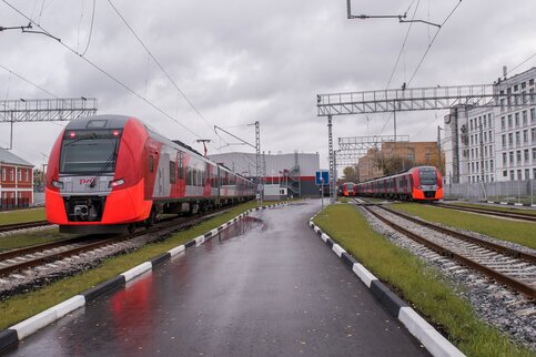
The rolling stock on the MCC is represented by high-speed electric trains "Lastochka" manufactured by Siemens AG. Trains consist of 5 cars.
Operation of the electric train is possible at ambient temperatures from −40°C to +40°C. The cars are equipped with double-leaf sliding doors, two on each side of the car.
 The electronics of the cars contain built-in lighting, loudspeakers, and digital information displays. To recharge mobile devices, the carry-on luggage compartments have built-in electrical sockets designed for 220v AC voltage.
 The head carriages of the train have bathrooms with dry toilets.(one per carriage), the bathrooms are equipped with special equipment for people with limited mobility.
There are 28 Lastochka high-speed electric trains running on the MCC. The train moves almost silently and can accelerate to 120 kilometers per hour. During peak hours, trains run every six minutes, at other times - at intervals of 11–15 minutes. The total duration of the trip around the ring is about 75-85 minutes.
Technologies
"Smart" escalators with motion sensors
Energy-saving escalators have been installed on the Moscow Central Circle (MCC). Smart escalators start moving only when passengers approach them. Accordingly, if there are no passengers on the escalator, it automatically slows down and stops.
Opening doors “On demand”
Doors on trains open at the request of passengers. The doors open only when the train is completely stopped on the platform, and only when the doors are ready to open, and a special green signal lights up.
 There are special stickers on the outer and inner sides of the doors informing that before entering or exiting, you must press the corresponding button to open the doors.
 Thermal curtain / Climate control system
In cold weather, electric trains on the Moscow Central Circle will include a thermal curtain on the doors. The thermal curtain turns on automatically at stops, when the doors are opened.
“Warm air is exhausted directly in front of the doors in the car, creating a thermal curtain and preventing cold air from entering inside,” the press service of JSC Russian Railways.
The thermal curtain will protect the carriage from sudden temperature changes and will be able to maintain a comfortable temperature for passengers at any time of the year.
MCC cars have an automatic heating system that turns on when the ambient temperature drops below the air temperature in the train. An antibacterial air disinfection system is integrated into the climate control of trains, which will protect passengers from all kinds of infections and viruses in the carriages, which is undoubtedly a relevant technology. solution for public transport
The history of the Small Ring of the Moscow Railway is more than a hundred years old. Back in 1908, the circular route was opened for cargo transportation in 9 directions of the Moscow and 1 direction of the Oktyabrskaya railways. In 2012, the ring had 12 operating stations.
Now the Moscow Ring Railway is a “light metro” under construction, a new ground mode of transport integrated into the overall metropolitan system and allowing passengers to make convenient transfers to buses and trams, metro and electric trains.
The opening of the reconstructed tracks is just around the corner, so it’s time to tell Muscovites and guests of our city in more detail about their advantages.
Latest news about the Moscow Ring Railway
- At a meeting in mid-April 2016, Vladimir Putin was informed that the first Moscow Ring Railway trains would be launched in September 2016. Further work on the construction of the small ring will be concentrated at the transfer points.
- In the twentieth of December, updated metro maps appeared in the capital's subway, which included the Small Ring of the Moscow Railway. This was done specifically so that passengers could get acquainted with pleasant prospects in advance and plan future routes.
- The Moscow Ring Railway will have a modern system for informing passengers via smartphones - for example, a user, being in a specific point in the capital, will be able to receive a message about which station is nearby and how long the train will arrive at it.
- According to the General Director of the Moscow Ring Railway, Alexei Zotov, train intervals on the Small Ring can be reduced to 2-3 minutes if necessary. In general, trains will run according to the subway schedule - with 6-minute intervals during peak hours and 12-minute intervals at other times.
- CCTV cameras will be installed at all stops and transport hubs on the Moscow Circle, which will help maintain the proper level of security.
- Everyone knows that the capital’s metro is an architectural monument that amazes with its grandeur even people who are used to riding it every day. But the “light metro” will also be an interesting piece of architecture, albeit a modern one. Thus, it became known that its stations will be illuminated in different colors in the evening, which will probably look very interesting under the transparent roof.
- The Moscow Ring Road will be fully adapted for use by people with disabilities. In the ticket office areas of each station there is a special ticket office for wheelchair users, the window height of which is less than a meter.
The section is constantly updated with up-to-date information.
Moscow Ring Railway in numbers

The small ring is:
- 54 km railway tracks, and taking into account the entrances and adjacent branches - 145 km;
- 32 stopping points for future passenger transportation and 12 existing freight stations before the start of global reconstruction;
- 212 billion rubles., invested in repair work;
- 20 minutes time saved when traveling around the center of the capital;
- 300 million passengers who will use the “light metro” by 2025;
- before 100 pairs compositions per day.
Moscow Ring Railway station diagram on the map
The stations of the Small Ring Railway will be full-fledged transport hubs (TPU). This means that they will house offices, cafes, shops, and shopping malls. At each station there is a transfer to ground public transport.
The Moscow Ring Railway will include 32 stations. Let's divide them into categories.

Stations from which you can only transfer to ground transport
Koptevo, Presnya, Belokamennaya, Sokolinaya Gora, ZIL, Sevastopolskaya, Novopeschanaya, Khodynka, Volgogradskaya, Park of Legends
Stations from which a transfer to the metro is implied
Vladykino, Botanical Garden, Open Highway, Cherkizovo, Izmailovsky Park, Enthusiasts Highway, Ryazanskaya, Dubrovka, Avtozavodskaya, Gagarin Square, Luzhniki, Kutuzovo, Shelepikha, Khoroshevo, Voykovskaya, Okruzhnaya
Stations from which you can transfer to the Russian Railways radial line
Streshnevo, Nikolaevskaya, Yaroslavskaya, Andronovka, Novokhokhlovskaya, Warsaw
Stations that allow transfers to both the metro and the Russian Railways radial line
District, Ryazan, City
Construction plan and when will it open?
The reconstruction of the Small Ring, which will result in high-speed passenger traffic, began in 2011. Previously, it was planned to launch the light metro in four stages. Traffic on the section of the first stage Presnya - Kanatchikovo was going to be launched at the end of 2014, and on the section of the second, third and fourth stages Presnya - Lefortovo - Kanatchikovo - at the end of 2015.
Nevertheless, it was decided not to rush and launch the ring when it was fully ready - the project was too complex and large-scale.
In December 2015, trains on the Moscow Ring Road were supposed to depart in test mode, but as of the third quarter of 2015, the work was 70% completed.
It is expected that no earlier than the fall of 2016, full-fledged passenger transportation will be established on the Small Ring.
Moscow Ring Railway and World Cup 2018
Some time ago, information was announced that the Moscow Ring Road would be reconstructed for the 2018 FIFA World Cup. But now, according to those in charge, traffic along it will be launched in the fall of 2016.
Fares on the Moscow Ring Railway and train intervals

The cost of travel on the Small Ring will be the same as on the subway. The same tariffs and passes will apply here, which, you see, is very convenient for passengers.
Light metro trains will run every 6 minutes.
- The Moscow Ring Railway is called the “road of the future”. Thanks to it, the “deserted” industrial zones of the capital will find a second wind and will be included in a busy transport ring.
- The Small Ring will connect the gardening estates of Moscow, which is also very convenient for its guests and residents. We are talking about Sparrow Hills, the Mikhailovo and Streshnevo estates, the Botanical Garden, VDNKh, Losiny Ostrov National Park.
- Trains on the Moscow Ring Railway will be able to accelerate to 120 km/h, so travel is guaranteed. The cabin provides free Wi-Fi, sockets for phones and other gadgets, and a climate control system.
- The tracks of the Moscow Ring Railway are already called “velvet” - Muscovites will not hear the sound of wheels, and special screens will protect them from excess noise.
Official website of the Moscow Ring Railway
The largest city in Europe, Moscow, is growing and developing year by year. It’s great that in our time we can observe such positive changes as the growth in the number of modern high-quality roads, metro stations and a fundamentally new type of transport that combines the speed and accessibility of the underground with the ability to transfer to buses, trams, and trolleybuses. We are confident that the Small Ring Railway and its trains will quickly gain popularity among residents of the capital, who value time like no one else.
Map of MCC metro stations in Moscow
MCC scheme- map of metro stations in Moscow
Map of MCC metro stations, with all stops indicated on the map. Initially it was called the Moscow Ring Railway (MKZhD), then the Second Moscow Ring Line, and was finally established under the name Moscow Central Circle (MCC). In fact, this is a city ground train, which differs from all others in its increased comfort and unearthly convenience.
Movement interval: 6 minutes (before lunch and in the evening on weekdays) and 12 minutes at night and on weekends.
Transportation is carried out by high-speed electric trains ES1, ES2G and ES2GP (or, more simply, Lastochka). Each consists of 5 carriages with a capacity of 1200 passengers. With air conditioning and toilets. Now it is possible to transport bicycles (in a regular metro you are allowed to transport them assembled).
The railway in Moscow was built back in 1908 by engineer Rashevsky. Its length was 54 kilometers.
Currently, 26 metro stations are open. Five more are planned to be completed a little later (they will be entered on the map in a timely manner).
Available MCC stations in Moscow: Okruzhnaya, Vladykino, Botanical Garden, Rostokino, Belokamennaya, Rokossovsky Boulevard, Lokomotiv, Izmailovo, Sokolinaya Gora, Entuziastov Highway, Andronovka, Nizhegorodskaya, Novokhokhlovskaya, Ugreshskaya, Dubrovka, Avtozavodskaya, ZIL, Verkhniye Kotly, Krymskaya, Ploshchad Gagarina, Luzhniki, Kutuzovskaya, Business Center, Shelepikha, Khoroshevo, Zorge, Panfilovskaya, Streshnevo, Baltiyskaya, Koptevo, Likhobory.
Unfortunately, not all points have heated ground transfers; in many crossings you will have to walk on foot along the street. But according to the diagrams drawn on the street, you can easily and accurately get from one place to another.
Moscow Central Circle - metro station map
You may find this MCC diagram more convenient:
Moscow metro map 2020, detailed map with current data for this month.
MCC and Moscow metro map 2018
Moscow Central Circle and metro map
Scheme of the Moscow Central Circle
 MCC station map
 MCC station diagram on the map of Moscow
 MCC station diagram on the map of Moscow
 Moscow Central Interchange Ring
 free MCC transfers
 Helpful information
No matter how banal it may sound, the pace of human life is accelerating day by day. A person is constantly in a hurry to somewhere: to work, to school, to university. In addition to proper time management, a well-functioning transport system helps you get everything done. One of its parts is the MCC or Moscow Central Circle.
History and layout of the MCC
In the past, the ring had a different name - the Moscow Circular Railway. The first mentions of it date back to the end of the 19th century, a time when the industrial boom was actively developing. Back then, goods were transported using dray cabs. The process required a lot of effort and time. That is why tycoon F.I. Chizhov proposed the idea of building a ring road. On the one hand, it was just in time. But on the other hand, a number of problems arose.
As it turned out, the state owns only 5% of all railways. All others are private property. Each has its own rules and prices. It took a lot of time to resolve this issue. But by the end of the 19th century, most of the roads became state-owned.
The order for the construction of the Moscow Circular Railway was given by Emperor Nicholas II on November 7, 1897. The commencement ceremony took place on August 3, 1903.
Moscow MCC map of those times included several objects:
- 22 branches connecting to the main railway tracks;
- 14 stations;
- 2 stopping points;
- 3 telegraph posts;
- 72 bridges, including those that cross the Moscow River;
- 30 overpasses;
- 185 culvert structures;
- 19 buildings for passengers;
- 30 houses;
- 2 houses for employees;
- 2 baths;
- 2 reception rooms.
The work was carried out under the supervision of the best Russian engineers and architects. These include N. A. Belelyubsky, L. D. Proskuryakov, A. N. Pomerantsev.
Now MCC station map looks like that:
- 31 stations;
- 17 stations for transfer to other metro lines;
- 10 stations for transferring to trains.
More than 200,000,000,000 rubles were spent on the construction of the structure. The total length of roads is 54 km. The round trip will take 84 minutes. Each train running between stations can accommodate 1,200 passengers.
Moscow metro map with MCC, trips and statistics
In fact, the MCC is part of the Moscow metro. In the documents it is designated as the Second Ring Line of the metro. This transport system is inextricably linked with it in the form of fares and transfers. On metro maps, routes are indicated by a white line with a red border. Each of them has the signature of the MCC and a serial number.
Transportation is carried out by more than three dozen Lastochka trains. Each of them accommodates 1,200 people. The maximum speed reaches 120 km/h, but the operating speed will remain at 40-50 km/h. Train intervals range from 5 to 15 minutes. It all depends on the time of day. During rush hour they will travel more often.
All Lastochkas are equipped with soft seats and climate control systems. Passengers have the opportunity to connect to WI-FI and even charge their gadgets.
Trains do not have vestibules. However, their wide double doors make it easy to transport passengers with limited mobility.
MCC has a lot of features and nuances. The figures below will help you see how ambitious the idea for its construction was.
- The ring road, which later became the MCC, was built 111 years ago.
- 130 pairs of trains pass here every day.
- To establish regular traffic, the state had to spend more than 70 billion rubles.
- Thanks to the work of the MCC, the Koltsevaya metro line has been decongested by 15%.
- In the first year, 75 million people were transported by Lastochkas.
- MCC provided citizens with 40,000 jobs.
- There are car parks near most of the stations.
- According to the plan, trains will be able to transport more than 300,000,000 people within a year.
Thanks to the ring, it was possible to significantly relieve urban transport.
So, MCC is a good alternative to cars. This is the absence of traffic jams, affordable travel costs and the ability to be punctual. Metro map with MCC will show how and at which station you can transfer to a train in the desired direction, and the availability of parking lots and convenient transition to the station will save both time and effort.
The first stage of the Moscow Central Circle will take place on September 10. The online publication site answered the most important questions about the new type of urban transport.
What it is?
The Moscow Central Circle is a network that connects the metro and radial lines of suburban railways. It used to be called the Moscow Ring Railway. The MCC runs near the Third Ring Road in the southeast and west of the city and in the middle between the Third Transport Ring and the Moscow Ring Road in the north of the capital.
The main task of the road is to shorten the path from one point remote from the city center to another. According to experts, the launch of the railway should reduce travel time by an average of 20 minutes, relieve congestion on the Circle Subway Line by 15 percent, and the city’s central stations by 20 percent.
How many stations will open on the MCC?
The ring includes 31 stations, each of which provides transfers to other types of public transport. 17 stations will be connected to 11 metro lines, 10 to radial railway lines.
At the first stage, 26 stations will be available to passengers, reports the press service of the Moscow Construction Complex, citing Deputy Mayor for Urban Development Policy Marat Khusnullin. The rest will begin work before the end of the year.
Until 2018, the connection between MCC stations and metro stations, radial railway lines and surface urban transport will gradually improve.
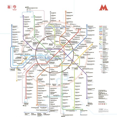
Photo: MCC press center in the Moscow metro
Where can I transfer from the MCC?
In total, with the launch of the MCC, Muscovites and guests of the capital can make more than 350 transfers, and travel time when moving around the capital will be reduced by three times.
Passengers will be able to freely change trains when traveling on the following routes: Metro – MCC – Metro; Metro – MCC; MCC – Metro – Monorail; Monorail – Metro – MCC – Metro.
There are also transfers from trains to buses, trolleybuses and trams. The surface transport schedule will be adjusted to the MCC schedule.
The intervals of ground transport routes serving the ring have been approximately 10 minutes since September 8. In the future, they are planned to be reduced to 6–8 minutes, so that passengers can almost immediately transfer from the MCC to ground transport.
Territory maps have been updated for more than four thousand ground transport stops, and 15 stops now have stations on the new ring.
It will also be possible to get to the new railway line by personal transport: special parking lots will be installed at 13 stops.
How to navigate the MCC?
In total, several versions of the MCC scheme have been prepared. On one of them, it is plotted on a map of the city with the designation of suburban railway lines, as well as metro lines, including the Third Interchange Circuit under construction.
In the second, the MCC map is included in the currently used metro map and is indicated there as the 14th metro line. In total, 50 thousand new schemes will be posted in the subway. The updated maps will also contain information about how long it will take to transfer from the metro station to the MCC station.
The ring stations themselves are equipped with navigation panels in Russian and English. Braille will be installed for visually impaired passengers. Also at each station there will be boards with train arrival times. Several of them will have “Live Communication” counters.

Where can I find detailed information about the MCC?
A section dedicated to the Moscow Central Circle has appeared on the official website of the capital's metro.
The new page contains information about the history of the creation of the MCC and the modern Lastochka trains running around the ring. Also, site visitors can familiarize themselves with the map of transfers from the metro to the MCC and select convenient routes.
In addition, a page for the central ring was opened on the Unified Transport Portal. Here you can also get detailed information about the routes taken and the time spent on the road.
What tickets will be valid on the MCC?
The tickets for the MCC are the same as for the metro. In the first month after opening, travel will be free.
Passengers using a Unified or Troika card purchased before September 1 need to renew their travel cards. Single can be renewed at the metro ticket office, Troika can be renewed through a machine by topping up the card with any amount.
Social cards do not require updating. The same applies to passes purchased in September.
It will be possible to buy tickets at the ring stations both in cash and by cards. They also plan to introduce a contactless fare payment system, which will allow you to pay for travel using a mobile phone, as well as the PayPass/PayWave system - money will be debited automatically if you attach a bank card to the validator.
The same tariffs will apply on the MCC as in the metro.
- one trip – 50 rubles;
- one train with a Troika card – 32 rubles;
- 90 minutes – 60 rubles.
Will there be any benefits at the MCC?
All benefits valid in the metro will remain. More than three million capital beneficiaries will receive the right to free travel along the second ring, including:
- pensioners;
- disabled people and participants of the Great Patriotic War;
- participants in the defense of Moscow;
- home front workers;
- residents of besieged Leningrad;
- former prisoners of Nazi camps, prisons and ghettos;
- Heroes of the Soviet Union;
- Heroes of the Russian Federation;
- Heroes of Socialist Labor and full holders of the Orders of Glory and Labor Glory of three degrees;
- labor veterans;
- honorary donors (USSR, Russia or Moscow);
- one of the parents and children from large families;
- orphans and children left without parental care, and their guardians (trustees);
- schoolchildren and students.

What schedule will the MCC operate on?
The MCC will operate according to the same schedule as the metro – from 5:30 to 01:00.
During peak hours, trains will run at intervals of six minutes; at normal times, trains will have to wait 15 minutes.
How long will it take to travel along the MCC?
Time in which you can travel the entire ring: 84 minutes, including stops. Passengers will not have to go to the Circle Line of the metro to get, say, from Mezhdunarodnaya to Leninsky Prospekt or from Vladykino to Rokossovsky Boulevard. With the opening of the road, covering these sections will take 10-12 minutes instead of 28-39, respectively.
What trains will travel on the MCC?
They will carry passengers. It is planned to equip all rolling stock with energy-saving electrical equipment, video cameras, air conditioning, phone chargers and free Wi-Fi.
Each "Swallow" will have five carriages. The two head cars will have two toilets, which are adapted for people with limited mobility, and there will be bins at the exits of the train.
In the first months, passengers will open the doors of Lastochkas on the MCC on their own. For this purpose, special buttons will be installed on the door leaves outside and inside the car. They will only be active when the train is completely stopped. A nearby green indicator will indicate that the button is working.
Will trains indicate the travel time to the next station?
All MCC trains will have video screens on which they will broadcast a display counting down the travel time to the next station. Passengers will be able to see how many minutes are left before arriving at the platform. The monitors will also show the speed of the train and changes in the metro schedule.
The first two trains with video information will be launched immediately in September, all trains will be equipped with screens by next fall. It is planned to install four screens in each carriage.
Is the MCC adapted for people with limited mobility?
Yes. All platforms are equipped with tactile tiles for ease of movement for visually impaired passengers. Elevators and escalators are installed at 26 transport hubs, and special lifts are installed at 5 transport hubs.
Will it be possible to travel with a bicycle or a stroller?
Yes. You can carry it on MCC trains; there are fasteners in the second and fourth cars. The first carriage of the trains will have seats for people with limited mobility. There is floor navigation inside the trains, it will tell you where to go for cyclists and where for people with mobility restrictions.
This information is also indicated on the outside of the trains. And next to each MCC transport hub, bicycle parking and bike sharing stations will be installed.
Are the MCC and the Third Interchange Circuit the same thing?
No. Many people confuse the Moscow Central Circle with, but they are not the same thing. The main difference is that the MCC is a railway connection, and the TPK is a subway ring.
TPK will become a new large ring of the Moscow metro. Its total length will be 59.5 kilometers with 28 stations. The first section of the circuit will be opened this year, and the entire line is planned to be launched within the next four years.
When did the idea of creating the MCC appear?
Construction of the road in 1903 under the personal supervision of the Moscow Governor-General, Grand Duke Sergei Alexandrovich.
Five years later, the first train was launched on the new railway; in just one day, four trains passed along the line. And while freight transportation has fully justified itself, passenger transportation has not.
At first, Muscovites were embarrassed by the high price of tickets, and in the late 20s - early 30s, bus and tram services were improved in the areas where the ring road ran, the popularity of trains fell, and in 1934 passenger service had to be closed.
They wanted to renew them in the 60s, but the proposal was never implemented, and in the late 80s the railway decided to restore the historical buildings and run passenger trains.
The modern idea of turning the road into a highway with metro connections appeared in 2001. And reconstruction began under Sergei Sobyanin in 2012.