Class: 7
Lesson objectives:
- continue the formation of a worldview idea about the integrity of the geographical shell of the Earth;
- introduction and development of the concepts “humidification coefficient”, “geographical zone”, “latitudinal zonality”, “altitudinal zonality”.
Lesson objectives:
- develop the ability to generalize knowledge and draw logical conclusions;
- continue to develop skills and abilities to work with geographic maps and analyze statistical materials.
Methods and techniques:
- verbal (teacher's story, conversation),
- visual (computer),
- partially search and research.
Lesson type: combined.
Teaching aids: textbook, wall map “Natural zones of the world”, atlas map “Geographical zones and natural zones”, disk “Geography. Land and People” (p. 34).
Lesson form: lesson using ICT.
During the classes
I. Organizational moment.
II. Updating knowledge. At this stage, there is a conversation with students on the topics “Natural complexes” (grade 6) and “Climates of the Earth” (grade 7) on the following questions:
- What components make up the geographic envelope?
- What does changing at least one of them lead to? Give examples.
- What is a natural area?
- What natural component gives the name to a natural area?
- What climate zones exist on Earth?
- What is the main reason for the diversity of climates?
To help students, a table is shown ( slide) “The supply of solar energy to the surface of the Earth at different geographic latitudes (per year).”
At the end of the conversation and discussion of the table, the teacher, together with the students, draws a conclusion.
The Sun heats the spherical surface of the Earth unequally: the areas above which it stands high receive the most heat. The farther from the equator, the greater the angle at which the rays reach the earth's surface and, therefore, the less thermal energy per unit area. Above the poles, the rays of the Sun only glide over the Earth. The climate depends on this: hot at the equator, harsh and cold at the poles. In almost every climatic zone of land, the oceanic parts are better moistened than the continental parts. Humidification also depends on the ratio of heat and moisture.
Students analyze the table ( slide) “Average annual indicators of natural zones.”
III. Learning new material.
Teacher. Humidification depends not only on the amount of precipitation, but also on the ratio of heat and moisture. The warmer it is, the more moisture that falls with precipitation evaporates. The same amount of precipitation can lead to excessive moisture in one zone and insufficient moisture in another. Thus, the annual precipitation amount of 150-200 mm in the cold tundra is excessive (swamps are formed), and in hot tropical deserts it is sharply insufficient: slide “Moistening coefficient for natural zones.”
Slide “Humidification coefficient, definition”, students write down in their notebooks. Students look at the pictures on slide“Humidity coefficient and natural zones of the world.”
The teacher draws a conclusion (students write it down in a notebook): the natural change in the components of nature and natural complexes when moving from the equator to the poles is the planetary law of geographic zoning, which was derived by the great Russian scientist V.V. Dokuchaev. The largest zonal divisions of the geographic envelope are geographic zones. Slide Students write down “Geographical zone, definition” in their notebooks.
Natural zones are formed within geographic zones. Students listen to the speaker ( slide) “Natural area, definition.” The teacher focuses students' attention on the fact that the change in natural zones on land is subject to the laws of geographic zonation. The regular change in natural components and natural complexes from the equator to the poles is latitudinal zonality (students write down the definition in their notebooks).
Teacher. Give examples of latitudinal zoning.
Students work with the map of the atlas “Geographical zones and natural zones of the world” and interactive map of the Disk“Natural zones of the world”, looking for answers to textbook questions, p. 35 “My geographical research”.
Discussion of the results of work with the atlas and textbook. The teacher draws students' attention to the meridional location of natural zones using the example of North America, considering slide“Examples of submeridional extension of natural zones.”
Teacher. In the mountains, latitudinal zonality gives way to altitudinal zonality. This is due to the specific natural conditions of the mountains:
- temperature change with altitude,
- influence of slope exposure, different
- moistening of windward and leeward slopes.
The regular change of natural zones and vegetation with height is called altitudinal zonation (the definition is written down in a notebook).
Students analyze slide p.90 “Altitudinal zonation in the Northern Andes.”
The teacher and the students draw a conclusion: the nature of the altitudinal zone depends on the height of the mountains and on the natural zone in which they are located. Altitudinal zones in the mountains successively change in height, similar to the change in natural zones on the plain. The lower altitude zone in the mountains will correspond to the natural zone in which the foot of the mountains is located.
Teacher. Natural zones are also formed in the World Ocean.
Students analyze the tables on the slide “Latitudinal zones of the World Ocean” and draw a conclusion: the properties of surface waters, the composition of vegetation and wildlife change from the equator to the poles.
IV. The final part of the lesson.
The teacher consolidates students' knowledge on the topic by asking them to determine how the natural areas of Africa are changing. Students work with maps of the atlas “Africa. Natural resources”, p.50, slide“Natural areas of Africa”, p.68.
The teacher evaluates the students' knowledge and skills. Gives marks.
V. Homework: §9, section “Formation of natural areas”, simulator p. 12, No. 8.
What determines the formation of natural areas? What natural areas stand out on our planet? You can answer these and some other questions by reading this article.
Natural zoning: formation of natural zones in the territory
The so-called planet of ours is the largest natural complex. It is very heterogeneous, both in the vertical section (which is expressed in vertical zonation) and in the horizontal (latitudinal) section, which is expressed in the presence of various natural zones on Earth. The formation of natural areas depends on several factors. And in this article we will talk specifically about the latitudinal heterogeneity of the geographical envelope.
This is a component of the geographical envelope, which is distinguished by a certain set of natural components with its own characteristics. These components include the following:
- climatic conditions;
- the nature of the relief;
- hydrological grid of the territory;
- soil structure;
- organic world.
It should be noted that the formation of natural areas depends on the first component. However, natural zones usually get their names from the nature of their vegetation. After all, flora is the most striking component of any landscape. In other words, vegetation acts as a kind of indicator that displays the deep (those that are hidden from our eyes) processes of the formation of a natural complex.
It should be noted that the natural zone is the highest level in the hierarchy of the physical-geographical zoning of the planet.
Factors of natural zoning
Let us list all the factors in the formation of natural zones on Earth. So, the formation of natural zones depends on the following factors:
- Climatic features of the territory (this group of factors includes the temperature regime, the nature of moisture, as well as the properties of the air masses dominating the territory).
- The general nature of the relief (this criterion, as a rule, affects only the configuration and boundaries of a particular natural zone).
The formation of natural areas can also be influenced by proximity to the ocean, or the presence of powerful ocean currents off the coast. However, all these factors are secondary. The main root cause of natural zonality is that different parts (belts) of our planet receive unequal amounts of solar heat and moisture.

Natural areas of the world
What natural zones do geographers identify today on the body of our planet? Let's list them from the poles to the equator:
- Arctic (and Antarctic) deserts.
- Tundra and forest-tundra.
- Taiga.
- Broad-leaved forest zone.
- Forest-steppe.
- Steppe (or prairie).
- Semi-desert and desert zone.
- Savannah zone.
- Tropical rainforest zone.
- Wet zone (hylea).
- Rain (monsoon) forest zone.
If we look at the map of the natural zonality of the planet, we will see that all natural zones are located on it in the form of belts in a sublatitudinal direction. That is, these zones, as a rule, extend from west to east. Sometimes this sublatitudinal direction can be violated. The reason for this, as we have already said, is the topography of a particular territory.

It is also worth noting that there are simply no clear boundaries between natural areas (as shown on the map). Thus, almost each of the zones smoothly “flows” into the neighboring one. At the same time, border “zones” can very often form at the junction. For example, these are semi-desert or forest-steppe zones.
Conclusion
So, we have found out that the formation of natural areas depends on many factors. The main ones are the ratio of heat and moisture in a particular area, the properties of the prevailing air masses, the nature of the relief, and so on. The set of these factors is the same for any territory: continent, country or small region.
Geographers identify on the surface of our planet over a dozen large natural zones, which are elongated in the form of belts and replace each other from the equator to the polar latitudes.
Natural zones of the Earth or natural-living zones are large areas of land with the same characteristics: relief, soil, climate and special flora and fauna. The formation of a natural zone depends on the relationship between the level of heat and moisture, that is, as the climate changes, the natural zone also changes.
Types of Natural Areas of the World
Geographers identify the following natural zones:
- Arctic desert
- Tundra
- Taiga
- Mixed forest
- broadleaf forest
- Steppe
- Deserts
- Subtropics
- Tropics

Rice. 1. Mixed forest
In addition to the main zones, there are also transitional zones:
- Forest-tundra
- Forest-steppe
- Semi-desert.
They share the features of two neighboring main zones. This is the complete official list of zones.
Some experts also identify such natural areas as:
TOP 4 articleswho are reading along with this
- Savannah;
- Monsoon forests;
- Equatorial forests;
- Highlands or altitudinal zones.
High belt zones have their own internal divisions.
Here are the following areas:
- Broad-leaved forest;
- Mixed forest;
- Taiga;
- Subalpine belt;
- Alpine belt;
- Tundra;
- Zone of snow and glaciers.
Location of zones- strictly vertically, from the foot to the top: the higher, the more severe the climatic conditions, lower the temperature, lower the humidity, higher the pressure.
The names of natural areas are not accidental. They reflect their main characteristics. For example, the term "tundra" means "plain without forest." Indeed, only a few dwarf trees can be found in the tundra, for example, polar willow or dwarf birch.
Zone placement
What are the patterns of location of natural climatic zones? It's simple - there is a strict movement of the belts along latitudes from the North (North Pole) to the South (South Pole). Their placement corresponds to the uneven redistribution of solar energy on the Earth's surface.
You can observe a change in natural zones from the coast inland, that is, relief and distance from the ocean also affect the location of natural zones and their width.
There is also a correspondence between natural zones and climatic zones. So, within what climatic zones are the above natural zones located:
- Equatorial belt- moist equatorial forests with areas of moist evergreen forest and rain forest where short dry periods are observed;
- Subequatorial belt- monsoon forests and savannas with areas of oceanic rain forests and monsoon deciduous forests;
- Tropical zone- savannas, tropical forests, tropical deserts and semi-deserts;

Rice. 2. Savannahs
- Subtropical zone- zone of evergreen forest, steppe and desert;
- Temperate zone- deserts, semi-deserts, steppe zone, mixed, deciduous and coniferous forest zone;
- Subtropical zone- forest-tundra and tundra;
- Arctic belt- tundra and arctic desert.
Based on this relationship, differences in climate, soil type and landscape can be observed in the same natural area.
Geographical position
Knowing where a particular natural area is located, you can indicate its geographical location. For example, the Arctic desert zone occupies the territories of Antarctica, Greenland and the entire northern tip of Eurasia. The tundra occupies large areas of countries such as Russia, Canada, and Alaska. The desert zone is located on continents such as South America, Africa, Australia and Eurasia.
Characteristics of the main natural areas of the planet
All natural areas differ in:
- relief and soil composition;
- climate;
- animal and plant world.
Adjacent zones may have similar characteristics, especially where there is a gradual transition from one to another. Thus, the answer to the question of how to define a natural area is very simple: note the climate features, as well as the features of flora and fauna.
The largest natural zones are: forest zone and taiga (trees grow everywhere except Antarctica). These two zones have both similar characteristics and differences inherent only to the taiga, mixed forest, broad-leaved forest, monsoon and equatorial forests.
Typical characteristics for a forest zone:
- warm and hot summers;
- large amounts of precipitation (up to 1000 mm per year);
- the presence of deep rivers, lakes and swamps;
- predominance of woody vegetation;
- diversity of the animal world.
The largest areas are equatorial forests; they occupy 6% of all land. The greatest diversity of flora and fauna is characteristic of these forests. 4/5 of all plant species grow here and 1/2 of all land animal species live here, many of which are unique.

Rice. 3. Equatorial forests
The role of natural areas
Each natural zone plays its own special role in the life of the planet. If we consider natural zones in order, we can give the following examples:
- arctic desert, despite the fact that it is almost completely an icy desert, it is a kind of “pantry” where multi-ton reserves of fresh water are stored, and also, being the polar region of the planet, it plays a key role in shaping the climate;
- climate tundra keeps the soils of the natural zone frozen for most of the year and this plays an important role in the planet’s carbon cycle;
- taiga, as well as equatorial forests are a kind of “lungs” of the Earth; They produce the oxygen necessary for the life of all living things and absorb carbon dioxide.
What is the main role of all natural areas? They store a large amount of natural resources that are necessary for human life and activity.
The global geographical community has long come up with both color symbols for natural areas and emblems that define them. Thus, Arctic deserts are indicated by blue waves, and simple deserts and semi-deserts are indicated by red waves. The taiga zone has a symbol in the form of a coniferous tree, and the mixed forest zone in the form of coniferous and deciduous trees.
What have we learned?
We learned what a natural area is, defined this term and identified the main features of the concept. We learned what the main zones of the Earth are called and what intermediate zones exist. We also found out the reasons for such zonality of the geographical shell of the Earth. All this information will help you prepare for a geography lesson in 5th grade: write a report on the topic “Natural zones of the Earth”, prepare a message.
Test on the topic
Evaluation of the report
Average rating: 4.3. Total ratings received: 166.
1) Remember what a natural area is.
A natural complex is a part of the earth's surface with relatively homogeneous natural conditions.
2) What patterns exist in the distribution of natural zones of the Earth?
The location of natural zones is closely related to climatic zones. Like climate zones, they naturally replace each other from the equator to the poles due to a decrease in solar heat reaching the Earth's surface and uneven moisture. This change of natural zones - large natural complexes is called latitudinal zoning. A change in natural zones, as you know, occurs not only on the plains, but also in the mountains - from the foot to their peaks. With altitude, temperature and pressure decrease, up to a certain altitude the amount of precipitation increases, and lighting conditions change. Due to changing climatic conditions, natural zones are also changing.
3) What natural areas are located in Eurasia?
Arctic deserts, tundra and forest-tundra, taiga, mixed and broad-leaved forests, forest-steppes and steppes, semi-desert and desert.
4) What sources of geographic information can be used to characterize a natural area?
Observations, geographical maps, meteorological data.
*Use the picture to determine how natural areas are located in our country. Why don't all zones extend from the western to the eastern outskirts of the country? Which zones are located only in the European part of the country? How can this be explained?
The location of natural zones is closely related to climatic zones. Like climate zones, they replace each other from the equator to the poles due to a decrease in solar heat reaching the Earth's surface and uneven moisture. In Russia, the following natural zones replace each other from north to south: arctic deserts and semi-deserts, tundra and forest-tundra, taiga, mixed and deciduous forests, forest-steppes and steppes, variable-humid forests, deserts and semi-deserts. Not all natural areas extend from the western to the eastern borders of the country. This is due to the fact that Russia has a large latitudinal elongation and climatic conditions change as we move deeper into the continent. Only in the European part is there a natural zone of mixed and deciduous forests. This can be explained by the fact that in the interior regions there is not enough moisture for the formation of forests.
Questions in a paragraph
*There are evergreens in the tundra. How do you explain this fact? Name the representatives of the flora and fauna of the tundra that you know. Consider how they adapt to harsh climates.
There are many evergreen plants in the tundra. Such plants can use sunlight as soon as they are freed from the snow, without spending time and energy on the formation of new foliage. Flora - mosses, lichens, shrubs - crowberry, bearberry, wild rosemary, dwarf birch, willow. Tundra plants have distinctive shapes that help them make best use of the sun's heat and protect themselves from the wind. Cushions are formed, for example, by stemless gum and saxifrage. They are so dense that from a distance they resemble moss-covered stones. The fauna of the tundra is not rich in species, but quite large in quantity. What animals live permanently in the tundra? The indigenous inhabitants of the tundra include reindeer, lemmings, arctic foxes, wolves, and birds - the polar owl and the ptarmigan. Very rare animals are musk oxen.
*Determine on the map which of our country’s largest mineral deposits are located in the tundra zone.
Large industrial hubs have been created in the area of the cities of Nikel, Vorkuta and Norilsk. Non-ferrous metals are being mined in Norilsk; oil and gas are being actively extracted in the north of the Tomsk and Tyumen regions. The Arctic tundra zone contains a large supply of important natural resources such as uranium and oil.
Questions at the end of the paragraph
1. What components of nature form a natural area?
Plant communities, animal communities, soils, characteristic features of surface and groundwater runoff, water regime of rivers, exogenous processes of relief formation.
2. What determines the change in natural zones?
The change in natural zones occurs as a result of a natural change in the ratio of heat and moisture.
3. Using our country as an example, justify the pattern of changing natural zones.
On the territory of Russia there is a change from north to south of the following natural zones: arctic deserts, tundras, forest-tundras, taiga, mixed and broad-leaved forests, forest-steppes, steppes, semi-deserts.
4. Think about how the flora and fauna of the Arctic deserts are adapted to their habitat.
Plants do not form a closed vegetation cover, are small in size, and flowering plants have a very short growing season. Animals of the Arctic deserts have adapted to get food from the sea; many have thick white fur; birds inhabit the coasts.
5. Indicate the features of the tundra zone of our country and explain them.
A feature of the Russian tundra zone is its wide distribution and the identification of several subzones from north to south. From north to south, three subzones are distinguished: Arctic tundras are replaced by typical (moss-lichen) tundras, and then by shrubby ones of dwarf birch and polar willows.
6. Think about the reason for the strong vulnerability of the nature of the tundra zone.
Pollutants do not remain in place; air currents carry them over long distances. And the inhabitants of the tundra, especially lichens, are unusually sensitive to their effects. In the tundra, pollutants accumulate rather than being washed away by meltwater. Low temperatures inhibit the destruction of harmful compounds. Dozens of rivers and lakes are dying. Streams of fuel oil and diesel fuel from drilling rigs flow into the soil and water bodies all year round. The coast of the Arctic seas and the entire tundra are littered with ownerless barrels and rusty iron. Many settlements are in an unsanitary condition. There are practically no environmentally friendly enterprises. Thermal power plants smoke the sky. The smog settles on the white snow, dividing it with black, and areas of bare ground appear in places where the pollution is especially high. For many years not a single plant will grow here. Another problem of the tundra is uncontrolled hunting and poaching. Many species of plants and animals have become rare.
The warmth of the sun, clean air and water are the main criteria for life on Earth. Numerous climatic zones have led to the division of the territory of all continents and waters into certain natural zones. Some of them, even separated by huge distances, are very similar, others are unique.
Natural areas of the world: what are they?
This definition should be understood as very large natural complexes (in other words, parts of the Earth’s geographic zone), which have similar, homogeneous climatic conditions. The main characteristic of natural areas is the flora and fauna that inhabit the given territory. They are formed as a result of the uneven distribution of moisture and heat on the planet.
Table “Natural areas of the world”
Natural area | Climate zone | Average temperature (winter/summer) |
Antarctic and Arctic deserts | Antarctic, Arctic | 24-70°C /0-32°C |
Tundra and forest-tundra | Subarctic and subantarctic | 8-40°С/+8+16°С |
Moderate | 8-48°С /+8+24°С |
|
Mixed forests | Moderate | 16-8°С /+16+24°С |
Broadleaf forests | Moderate | 8+8°С /+16+24°С |
Steppes and forest-steppes | Subtropical and temperate | 16+8 °С /+16+24°С |
Temperate deserts and semi-deserts | Moderate | 8-24 °С /+20+24 °С |
Hardleaf forests | Subtropical | 8+16 °С/ +20+24 °С |
Tropical deserts and semi-deserts | Tropical | 8+16 °С/ +20+32 °С |
Savannas and woodlands | 20+24°С and above |
|
Variably humid forests | Subequatorial, tropical | 20+24°С and above |
Permanently wet forests | Equatorial | above +24°С |
This characteristic of the natural zones of the world is only for informational purposes, because you can talk about each of them for a very long time, and all the information will not fit into the framework of one table.
Natural zones of the temperate climate zone
1. Taiga. It surpasses all other natural zones of the world in terms of land area (27% of the territory of all forests on the planet). It is characterized by very low winter temperatures. Deciduous trees cannot withstand them, so the taiga is dense coniferous forests (mainly pine, spruce, fir, larch). Very large areas of the taiga in Canada and Russia are occupied by permafrost.
2. Mixed forests. Characteristic to a greater extent for the Northern Hemisphere of the Earth. It is a kind of border between taiga and deciduous forest. They are more resistant to cold and long winters. Tree species: oak, maple, poplar, linden, as well as rowan, alder, birch, pine, spruce. As the table “Natural Zones of the World” shows, the soils in the mixed forest zone are gray and not highly fertile, but are still suitable for growing plants.
3. Broad-leaved forests. They are not adapted to harsh winters and are deciduous. They occupy most of Western Europe, the south of the Far East, northern China and Japan. The climate suitable for them is maritime or temperate continental with hot summers and fairly warm winters. As the table “Natural zones of the world” shows, the temperature in them does not fall below -8°C even in the cold season. The soil is fertile, rich in humus. The following types of trees are typical: ash, chestnut, oak, hornbeam, beech, maple, elm. The forests are very rich in mammals (ungulates, rodents, predators), birds, including game birds.

4. Temperate deserts and semi-deserts. Their main distinguishing feature is the almost complete absence of vegetation and sparse fauna. There are quite a lot of natural areas of this nature; they are located mainly in the tropics. There are temperate deserts in Eurasia, and they are characterized by sharp changes in temperature across the seasons. Animals are represented mainly by reptiles.
Arctic deserts and semi-deserts
They are huge areas of land covered with snow and ice. A map of the world’s natural zones clearly shows that they are located in North America, Antarctica, Greenland and the northern tip of the Eurasian continent. In fact, these are lifeless places, and only along the coast are polar bears, walruses and seals, arctic foxes and lemmings, and penguins (in Antarctica). Where the ground is free of ice, lichens and mosses can be seen.

Equatorial rainforests
Their second name is rain forests. They are located mainly in South America, as well as in Africa, Australia and the Greater Sunda Islands. The main condition for their formation is constant and very high humidity (more than 2000 mm of precipitation per year) and a hot climate (20°C and above). They are very rich in vegetation, the forest consists of several tiers and is an impenetrable, dense jungle, which has become home to more than 2/3 of all types of creatures now living on our planet. These rain forests are superior to all other natural areas in the world. The trees remain evergreen, changing foliage gradually and partially. Surprisingly, the soils of humid forests contain little humus.
Natural zones of the equatorial and subtropical climate zone
1. Variably humid forests, they differ from rain forests in that precipitation falls there only during the rainy season, and during the period of drought that follows, the trees are forced to shed their leaves. The flora and fauna are also very diverse and rich in species.
2. Savannas and woodlands. They appear where moisture, as a rule, is no longer sufficient for the growth of variable-humid forests. Their development occurs in the interior of the continent, where tropical and equatorial air masses dominate, and the rainy season lasts less than six months. They occupy a significant part of the territory of subequatorial Africa, the interior of South America, partly Hindustan and Australia. More detailed information about the location is reflected in the map of natural areas of the world (photo).

Hardleaf forests
This climate zone is considered the most suitable for human habitation. Hard-leaved and evergreen forests are located along sea and ocean coasts. Precipitation is not so abundant, but the leaves retain moisture due to their dense leathery shell (oaks, eucalyptus), which prevents them from falling. In some trees and plants they are modernized into spines.
Steppes and forest-steppes
They are characterized by an almost complete absence of woody vegetation, due to the poor level of precipitation. But the soils are the most fertile (chernozems), and therefore are actively used by humans for farming. The steppes occupy large areas in North America and Eurasia. The predominant number of inhabitants are reptiles, rodents and birds. Plants have adapted to the lack of moisture and most often manage to complete their life cycle in a short spring period, when the steppe is covered with a thick carpet of greenery.
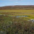
Tundra and forest-tundra

In this zone the breath of the Arctic and Antarctic begins to be felt, the climate becomes more severe, and even coniferous trees cannot withstand it. There is an abundance of moisture, but there is no heat, which leads to swamping of very large areas. There are no trees at all in the tundra; the flora is mainly represented by mosses and lichens. It is considered to be the most unstable and fragile ecosystem. Due to the active development of gas and oil fields, it is on the verge of an environmental disaster.
All natural areas of the world are very interesting, be it a desert that seems at first glance absolutely lifeless, endless Arctic ice or thousand-year-old rain forests with boiling life inside.